The Mass Rapid Transit (MRT) system is efficient, eco-friendly, and the cheapest way to almost every destination in Singapore.
Check out all current/future MRT & LRT lines of Singapore, maps & stations, and the best apps to download to travel efficiently and cheaply around the city.
As of January 2020, the MRT network encompasses 203 kilometers of route on standard gauge, with 122 stations in operation, spread across six lines set in a circle-radial topology and with an average daily ridership of 3.384 million in 2019.
The network is expected to double to a total length of almost 400 kilometers by 2040 as a result of ongoing expansion works to its six existing lines and the construction of three new lines.
The network is complemented by a small number of local Light Rail Transit (LRT) networks in the suburban towns of Bukit Panjang, Sengkang, and Punggol that link MRT stations with HDB public housing estates, bringing the combined length of the domestic heavy and light rail network to 231.6 kilometers, with a total of 159 stations in operation.


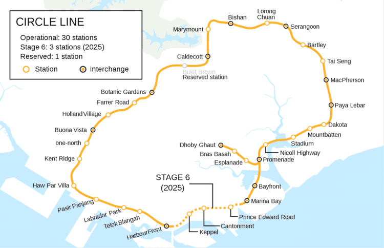
The Circle MRT Line (CCL) runs a currently incomplete loop from Dhoby Ghaut station in the city area of Singapore to HarbourFront station in the south via Bishan station in Central Singapore.
It also has a branch to Marina Bay station from Promenade station, which will be extended to Harbourfront station in the future to form a complete loop. Coloured orange on the rail map, the fully-underground line is 35.5 kilometres long with 30 stations. Travelling from one end of the line to the other takes about an hour.CC1 | NS24 | NE6 Dhoby Ghaut CC2 Bras Basah CC3 Esplanade CC4 | DT15 Promenade CC5 Nicoll Highway CC6 Stadium CC7 Mountbatten CC8 Dakota CC9 | EW8 Paya Lebar CC10 | DT26 MacPherson CC11 Tai Seng CC12 Bartley CC13 | NE12 Serangoon CC14 Lorong Chuan CC15 | NS17 Bishan CC16 Marymount CC17 | TE9 Caldecott CC18 Bukit Brown CC19 DT9 Botanic Gardens CC20 Farrer Road CC21 Holland Village CC22 | EW21 Buona Vista CC23 one-north CC24 Kent Ridge CC25 Haw Par Villa CC26 Pasir Panjang CC27 Labrador Park CC28 Telok Blangah CC29 NE1 HarbourFront

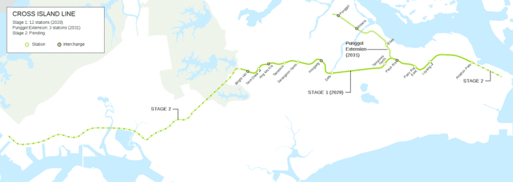
The Cross Island Line (CRL) is currently under planning and will be the eighth MRT line when built. The line will be colored lime on the rail map.
When completed, the line will begin in Changi, passing through Loyang, Pasir Ris, Hougang, Ang Mo Kio, Bukit Timah, Clementi, West Coast before terminating at Jurong Industrial Estate. The eastern leg of the line includes a segment that branches out from Pasir Ris and extends into Punggol.Names stated are working names, except for current operational stations. CR2 Aviation Park CR3 Loyang CR4 Pasir Ris East CR5 | EW1 | CP1 Pasir Ris CR6 Tampines North CR7 Defu CR8 | NE14 Hougang CR9 Serangoon North CR10 Tavistock CR11 NS16 Ang Mo Kio CR12 Teck Ghee CR13 | TE7 Bright Hill CP1 | EW1 | CR5 Pasir Ris CP2 Elias PE4 = CP3 Riviera CP4 NE17 PTC Punggol

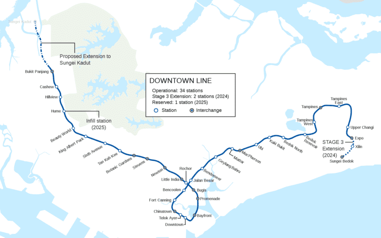
The Downtown Line (DTL) currently runs from Bukit Panjang station in the north-west to Expo station in the east via the Central Area.
Coloured blue on the rail map, the line serves 34 stations, all of which are underground. The DTL is the fifth MRT line on the network to be opened and the third line to be entirely underground.The line is set to be further extended in the near future. An extension of the line to Sungei Bedok, is under construction and is scheduled to begin operations in 2024, while a new infill station, Hume station, is planned to open in 2025.
An extension to connect with the North-South line at Sungei Kadut station is also being planned and set to open in the 2030s. When fully completed in 2024, the line will be about 44 kilometres long with 36 stations and will serve more than half a million commuters daily.
DT– NS6 Sungei Kadut T1 = BP6 Bukit Panjang DT2 Cashew DT3 Hillview DT4 Hume DT5 Beauty World DT6 King Albert Park DT7 Sixth Avenue DT8 Tan Kah Kee DT9 | CC19 Botanic Gardens DT10 | TE11 Stevens DT11 = NS21 Newton DT12 | NE7 Little India DT13 Rochor DT14 | EW12 Bugis DT15 | CC4 Promenade DT16 | CE1 Bayfront DT17 Downtown DT18 Telok Ayer DT19 | NE4 Chinatown DT20 Fort Canning DT21 Bencoolen DT22 Jalan Besar DT23 Bendemeer DT24 Geylang Bahru DT25 Mattar DT26 | CC10 MacPherson DT27 Ubi DT28 Kaki Bukit DT29 Bedok North DT30 Bedok Reservoir DT31 Tampines West DT32 | EW2 Tampines DT33 Tampines East DT34 Upper Changi DT35 | CG1 Expo DT36 | Xilin DT37 | TE31 Sungei Bedok

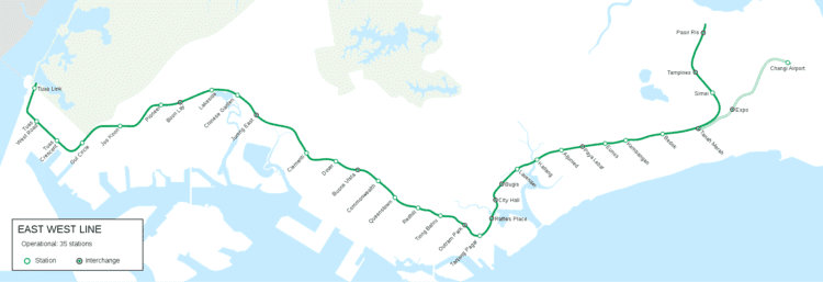
The East West Line (EWL) is running from Pasir Ris station in the east to Tuas Link station in the west, with an additional branch between Changi Airport and Tanah Merah stations.
It is the second Mass Rapid Transit line to be built in Singapore. The 57.2 kilometres line is the longest on the MRT network, with 35 stations, 8 of which (from Lavender to Tiong Bahru and Changi Airport stations) are underground. The line is coloured green on the rail map.EW1 | CR5 | CP1 Pasir Ris EW2 | DT32 Tampines EW3 Simei EW4 | CG Tanah Merah EW5 Bedok EW6 Kembangan EW7 Eunos EW8 | CC9 Paya Lebar EW9 Aljunied EW10 Kallang EW11 Lavender EW12 | DT14 Bugis EW13 | NS25 City Hall EW14 | NS26 Raffles Place EW15 Tanjong Pagar EW16 | NE3 | TE17 Outram Park EW17 Tiong Bahru EW18 Redhill EW19 Queenstown EW20 Commonwealth EW21 | CC22 Buona Vista EW22 Dover EW23 Clementi EW24 | NS1 | JE5 Jurong East EW25 Chinese Garden EW26 Lakeside EW27 | JS8 Boon Lay EW28 Pioneer EW29 Joo Koon EW30 Gul Circle EW31 Tuas Crescent EW32 Tuas West Road EW33 Tuas Link CG1 | DT35 Expo CG2 Changi Airport
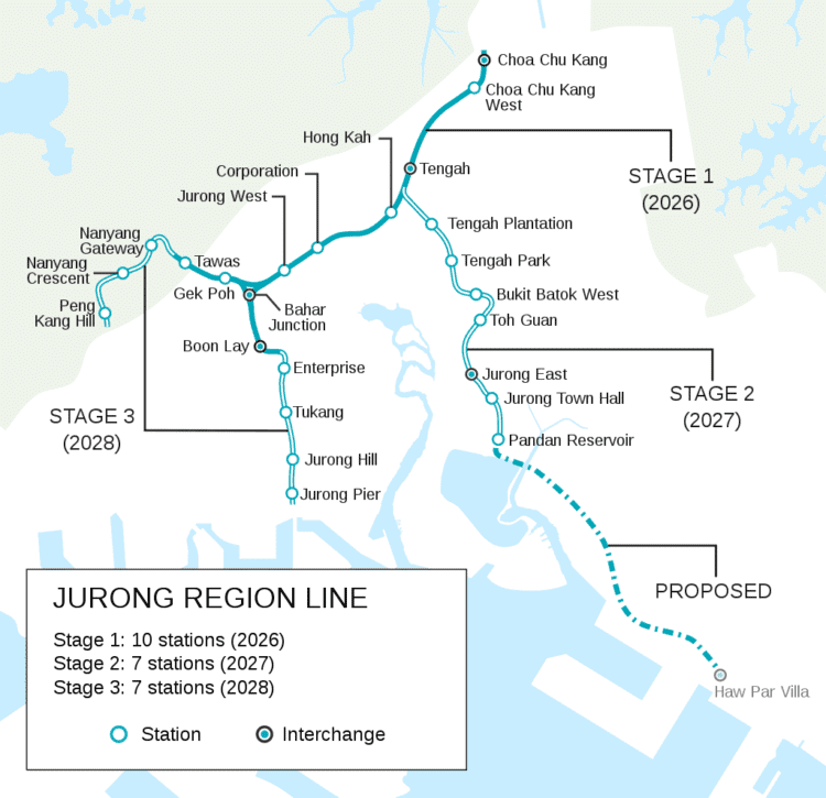
The Jurong Region Line (JRL) is an elevated MRT line which will open in 2026 to serve the western part of Singapore.
It reaches north to Choa Chu Kang, south to Jurong Pier, west to Peng Kang Hill and east to Pandan Reservoir and will be the seventh MRT line. The line is coloured turquoise on the rail map.The Jurong Region Line is the first MRT line to be built fully elevated with no underground or ground level sections.
JS1 | NS4 | BP1 Choa Chu Kang JS2 Choa Chu Kang West JS3 Tengah JS4 Hong Kah JS5 Corporation JS6 Jurong West JS7 Bahar Junction JS8 EW27 Boon Lay JW1 Gek Poh JW2 Tawas JE1 Tengah Plantation JE2 Tengah Park JE3 Bukit Batok West JE4 Toh Guan JE5 | NS1 | EW24 Jurong East JE6 Jurong Town Hall JE7 Pandan Reservoir JS9 Enterprise JS10 Tukang JS11 Jurong Hill JS12 Jurong Pier JW3 Nanyang Gateway JW4 Nanyang Crescent JW5 Peng Kang Hill


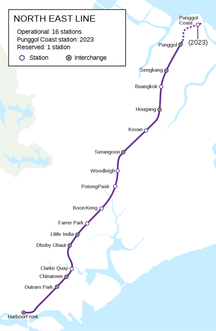
The North East Line (NEL) is the shortest MRT line in Singapore. It is a high-capacity line and runs from HarbourFront in the south-west to Punggolin the north-east.
It is currently 19.2 kilometres long with 16 stations and a full journey from one end to the other takes 33 minutes. The line is coloured purple on the rail map.It is the first MRT line in the network to use fully automated and driverless trains and is also the world's first fully underground and high-capacity driverless rapid transit line to use conventional steel-wheel technology.
The North East Line is also the first line to feature Art in Transit across all 16 stations and full Wireless@SG coverage in all 16 stations. It is also the first MRT line to run entirely underground.
Currently under construction is the North East line extension, a 2-kilometre extension of the line from Punggol through Punggol North including the new Punggol Downtown which will open in 2023. The single station extension will span 1.6 kilometres and will serve the future Punggol North area, along with the planned "creative cluster and learning corridor" in Punggol.
NE1 | CC29 HarbourFront NE3 | EW16 | TE17 Outram Park NE4 DT19 Chinatown NE5 Clarke Quay NE6 | NS24 | CC1 Dhoby Ghaut NE7 | DT12 Little India NE8 Farrer Park NE9 Boon Keng NE10 Potong Pasir NE11 Woodleigh NE12 | CC13 Serangoon NE13 Kovan NE14 | CR8 Hougang NE15 Buangkok NE16 | STC Sengkang NE17 | PTC | CP4 Punggol NE18 Punggol Coast

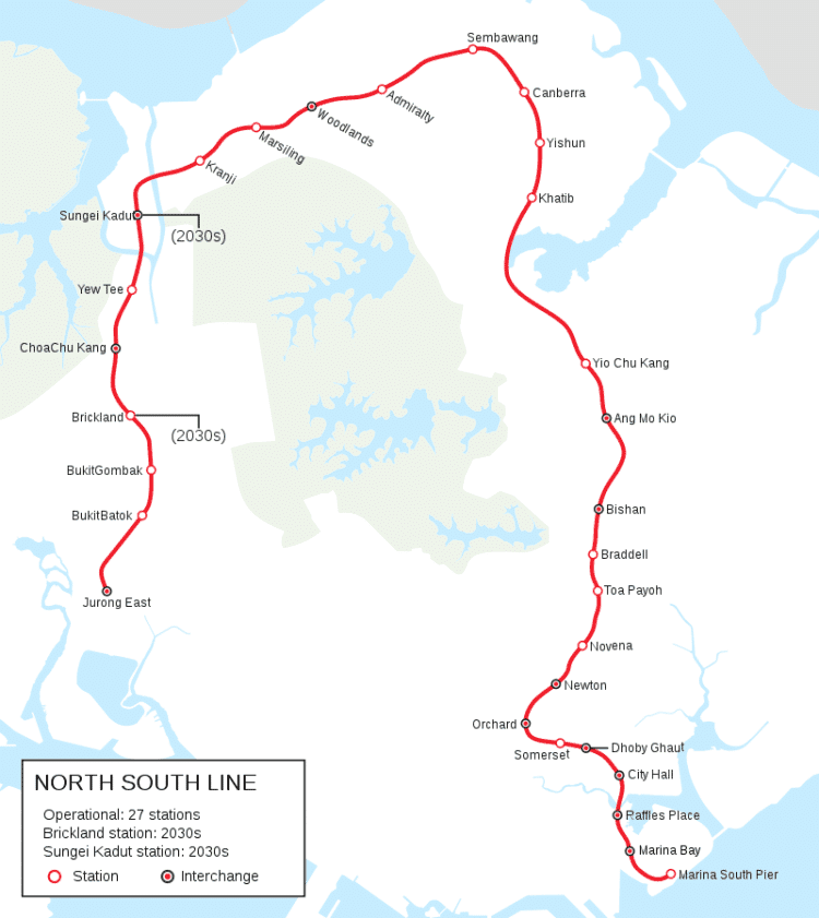
The North South Line (NSL) is coloured red on the rail map, is 45 kilometres long and serves 27 stations, 11 of which, between the Bishan and Marina South Pier stations, are underground.
It runs from Jurong East station, located in western Singapore, to Marina South Pier station in the Central Area, via Woodlands station in northern Singapore. The line operates for 19 hours a day (from approximately 5:30 am to around midnight), with headways of up to 3 minutes during peak hours and 7 minutes during off-peak hours.It is the first MRT line to be built in Singapore, with the first section from Yio Chu Kang station to Toa Payoh station beginning service on 7 November 1987, followed by an extension southwards to Raffles Place station on 12 December the same year and northwards to Yishun station on 20 December 1988. After the southern extension to Marina Bay station on 4 November 1989, the North South line was formed and split from the East West line. In the 1990s, the line extended to the north and west connecting to the Branch line via Woodlands through the Woodlands line extension.
Two more infill stations (Brickland and Sungei Kadut stations) on the line are being planned and are set to be opened in the 2030s.
NS1 | EW24 | JE5 Jurong East NS2 Bukit Batok NS3 Bukit Gombak NS3A Brickland NS4 | BP1 | JS1 Choa Chu Kang NS5 Yew Tee NS6 | DT– Sungei Kadut NS7 Kranji NS8 Marsiling NS9 | TE2 Woodlands NS10 Admiralty NS11 Sembawang NS12 Canberra NS13 Yishun NS14 Khatib NS15 Yio Chu Kang NS16 | CR11 Ang Mo Kio NS17 | CC15 Bishan NS18 Braddell NS19 Toa Payoh NS20 Novena NS21 = DT11 Newton NS22 | TE14 Orchard NS23 Somerset NS24 | NE6 | CC1 Dhoby Ghaut NS25 | EW13 City Hall NS26 | EW14 Raffles Place NS27 | CE2 | TE20 Marina Bay NS28 Marina South Pier

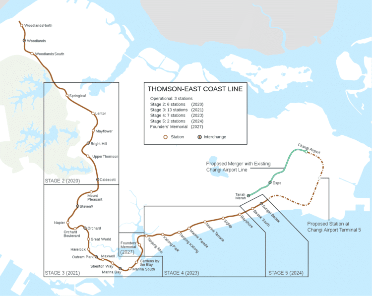
The Thomson–East Coast Line (TEL) is coloured brown on the rail map, it is fully underground serving 32 stations over 43 kilometres in length, and will be among the world's longest driverless rapid transit lines.
It will run along a combined north-south and east-west corridor, starting in the north at Woodlands town, passing through Upper Thomson and the towns of Ang Mo Kio and Bishan, before heading south to Orchard and Marina Bay, then running eastwards along the east coast through Kallang, Marine Parade and Bedok South, before ending at Upper East Coast.Thomson–East Coast Line will be extended to Changi Airport Terminal 5, which will start construction in 2020, and Changi Airport.The stretch of rail network between Tanah Merah and Changi Airport on the East West line will be converted to form part of the extension. The extension is expected to begin construction after 2022, with train services commencing by 2040.
TE1 RTS Woodlands North TE2 NS9 Woodlands TE3 Woodlands South TE4 Springleaf TE5 Lentor TE6 Mayflower TE7 | CR13 Bright Hill TE8 Upper Thomson TE9 | CC17 Caldecott TE10 Mount Pleasant TE11 | DT10 Stevens TE12 Napier TE13 Orchard Boulevard TE14 | NS22 Orchard TE15 Great World TE16 Havelock TE17 | EW16 | NE3 Outram Park TE18 Maxwell TE19 Shenton Way TE20 | NS27 | CE2 Marina Bay TE21 Marina South TE22 Gardens by the Bay TE22A Founders' Memorial TE23 Tanjong Rhu TE24 Katong Park TE25 Tanjong Katong TE26 Marine Parade TE27 Marine Terrace TE28 Siglap TE29 Bayshore TE30 Bedok South TE31 | DT37 Sungei Bedok TE32 | CR1 Changi Airport Terminal 5 CG2 | TE33 (from 2040) Changi Airport CG1 | DT35 | TE34 | DT35 (from 2040) Expo CG | EW4 | TE35 | EW4 (from 2040) Tanah Merah


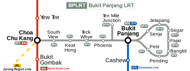
The Bukit Panjang LRT Line (BPLRT) is 7.6-kilometre and serves 13 stations in the neighbourhood of Bukit Panjang and Choa Chu Kang.
There are two services on the line: A and B terminate at Choa Chu Kang.Currently Operational
A: Choa Chu Kang - Senja Senja to Petir | Clockwise direction Operates during peak hours (Weekdays) only B: Choa Chu Kang - Petir Petir to Senja | Anti-clockwise directionBP1 | NS4 | JS1 Choa Chu Kang BP2 South View BP3 Keat Hong BP4 Teck Whye BP5 Phoenix BP6 | DT1 Bukit Panjang BP7 Petir BP8 Pending BP9 Bangkit BP10 Fajar BP11 Segar BP12 Jelapang BP13 Senja

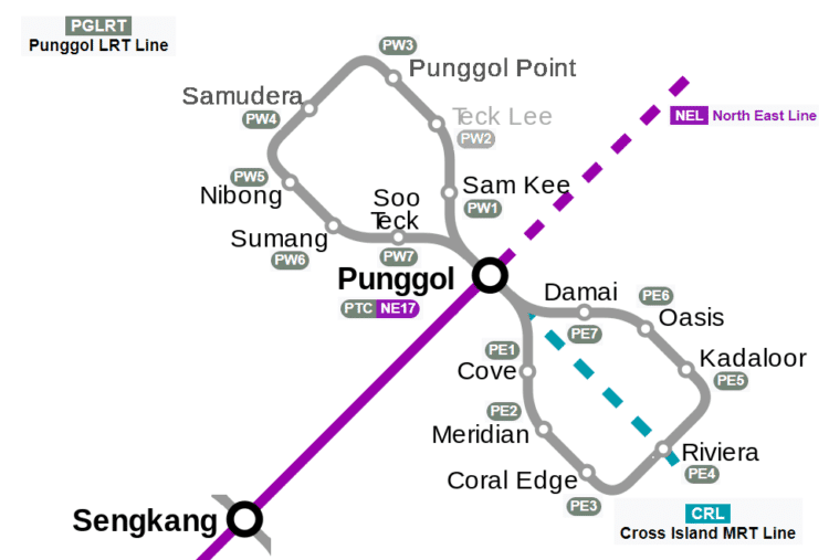
The Punggol LRT Line connects the residential districts and suburbs of Punggol to Punggol Town Centre, where it connects with the North East MRT line and the Punggol Bus Interchange.
The first phase is a 10.3-kilometre line with 15 stations in two loops.There are four services in total, with two services on each loop.
A: Punggol - Soo Teck | West Loop Soo Teck to Sam Kee, clockwise direction B: Punggol - Cove | East Loop Cove to Damai, anti-clockwise direction C: Punggol - Damai | East Loop Damai to Cove, clockwise direction D: Punggol - Sam Kee | West Loop Sam Kee to Soo Teck, anti-clockwise directionPTC | NE17 | CP4 Punggol
EAST LOOP
PE1 Cove PE2 Meridian PE3 Coral Edge PE4 = CP3 Riviera PE5 Kadaloor PE6 Oasis PE7 DamaiWEST LOOP
PW1 Sam Kee PW2 Teck Lee (Not in operation) PW3 Punggol Point PW4 Samudera PW5 Nibong PW6 Sumang PW7 Soo Teck

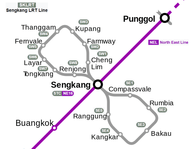
The Sengkang LRT Line connects the residential districts and suburbs of Sengkang to Sengkang Town Centre, where it connects with the North East MRT line, Sengkang Bus Interchange, Compass One and Compassvale Bus Interchange.
It is the second line of the LRT system in Singapore and is 10.7-kilometre longThere are four services in total, with two on each loop.
A: Sengkang - Renjong | West Loop Renjong to Cheng Lim, clockwise direction B: Sengkang - Cheng Lim | West Loop Cheng Lim to Renjong, anti-clockwise direction C: Sengkang - Compassvale | East Loop Compassvale to Ranggung, clockwise direction D: Sengkang - Ranggung | East Loop Ranggung to Compassvale, anti-clockwise directionSTC | NE16 Sengkang
EAST LOOP
SE1 Compassvale SE2 Rumbia SE3 Bakau SE4 Kangkar SE5 RanggungWEST LOOP
SW1 Cheng Lim SW2 Farmway SW3 Kupang SW4 Thanggam SW5 Fernvale SW6 Layar SW7 Tongkang SW8 Renjong

Citymapper - Transit Navigation
Citymapper is the ultimate transit app, making cities easier to use! Check nearby departures in real-time Find the fastest route combining bus, subway, train, ferry, taxi, car share, bike share, and walk Follow the step by step directions, including the best subway exit to reach the platform Receive alerts when your favorite lines are disrupted
App Store | Google Play
Explore Singapore MRT Map
Singapore's best MRT and LRT map! Up-to-date with all the metro lines for 2020; Works offline; Routeplanner, GPS, Google Maps; English and Chinese included.
App Store | Google Play
Map of Singapore offline
Map of Singapore offline works without connecting to the Internet. No need to pay for the internet in roaming.
App Store | Google Play
OneMap SG
New OneMap is the authoritative national map of Singapore with the most detailed and timely updated information developed by the Singapore Land Authority. There are also many useful day-to-day information and services contributed by government agencies.
App Store | Google Play
SINGAPORE City Guide Offline Maps and Tours
This Singapore Guide is your reliable and easy-to-use travel companion. Find directions with detailed offline maps, in-depth travel content, popular attractions, and insider tips with this Singapore City Guide.
App Store | Google Play
Singapore Maps
Streetdirectory App comes Offline maps & real-time bus timing
App Store | Google Play
Singapore Train Map (Offline)
Offline line maps for Singapore. It includes a complete set of offline maps for Mass Rapid Transit (MRT) and Light Rail Transit (LRT) from the official sources. High-Resolution Singapore MRT & LRT map. Most comprehensive up to date and the friendliest to use MRT Map of Singapore. Great for Singapore locals and tourists use. Latest offline Singapore MRT & LRT map. No data is needed. Designed for everyone from even first-time visitors to experienced commuters.
Google Play
Train Map: Singapore (Offline)
Offline line maps for Singapore. It includes a complete set of offline public transport maps for Mass Rapid Transit (MRT) and Light Rail Transit (LRT) from the official sources. No internet connection is required. You can zoom in, zoom out, scroll around. Quick, easy, and there when you need it! This app is excellent for visitors to Singapore and longtime residents alike.